


Tuesday, July 20, 2004
(Finally, the Hike!)
Well, I am sure that everyone who is following along remembers my trials and tribulations trying to go on the long hike in Dominica. Actually, let me back up a bit . . .
I know that I have said this before, but this time I am REALLY behind and I am sorry. I am writing this entry ABOUT July 20th, but at the moment it is currently August the 6th (making me exactly two weeks late). I have a valid excuse this time, though. The day of the hike brought interesting news when I got back to the boat. The guy in the office that is in charge of organizational movement on the ships in my department made an offhand comment that I wasn't expecting. He asked how I was doing on the Destiny, and I said that I liked it other than the room being hot and the bed too small (making it difficult to sleep). He said that that problem may be solved, as he was thinking of moving me before the end of the month, and that I would have two beds in my new room. Now, he had told me when I got on the Destiny that (unusually enough) I would be there for the whole contract, normally we get moved around a lot. I pointed out that having two beds that were way too small really isn't any more helpful than having one, and that my family was sailing with me on the Destiny in October. If he hadn't asked how I was doing, I wouldn't have even had a hint. All of this to say, THIS is why this is so late. The actual story will be in the next entry.
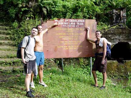
Anyway, I finally got to go on the hike that I had been trying to go on for some time. It was the last week that our assistant shore excursion manager was going to be here (and, as it turned out, also mine) and he had been wanting to go before he left. Ed (a good friend and one of the pursers) and Christian (the cable TV system manager) had also wanted to go. It is a flat fee, so the more people that go the cheaper it is.
The morning came and we were supposed to meet at the gangway just as the ship pulled in. We were to hike to the boiling lake, and it is a 7-hour round-trip hike. It also takes a half hour or so to get to the start of the hike, and obviously the same to get back. We can't get off the boat until around 9:30 am, and we have to be back on by 5:30, so our window of opportunity isn't exactly huge.
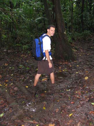
When I got to the gangway, I saw two immediate problems. Number one, I was the only person there. Number two, it was POURING. Now, I expect to get rained on in Dominica . . . it IS a rain forest. I even welcome it when hiking, as it is pretty hot there. However, to be drenched before even getting in the van isn't my idea of a great start. In the 45 minutes it took to actually get everyone in the van and going, the rain had pretty much stopped. At this point the driver of the van pointed out to me (as well as the three other guys in the group) that sandals weren't exactly proper hiking attire, and that I should have hiking boots or heavy tennis shoes. I pointed out that it was either these, or canvas high-tops, as I didn't bring hiking boots with me. I also pointed out that I had been hiking in Dominica several times, in pretty rough territory, and was GLAD to have sandals on each time. So, we set off.
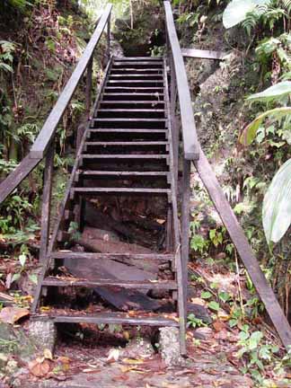
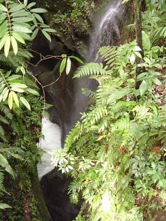
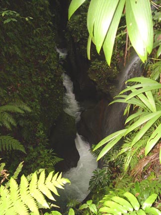
The start of the trail happens to be right where I swam up the crack in the rocks to see the waterfall. It is a beautiful area. I'm not sure that the start of the trail was the most heartening thing, though. I almost wonder if they don't bother replacing the two missing steps just to weed out people that this would tend to frighten. Early in the hike the guide pointed out an interesting plant. It is from the same family as the pineapple, but doesn't produce the fruit. It produces a large flower at some point, though.
Now, I'm going to stop and say here that there aren't going to be as many pictures of this trip as I would like. There are three reasons for this. Number one, the view is so vivid and panoramic, that it almost seems to reduce it too dramatically to flatten it, cut out a small window, and put it in print. I had the same feeling at the Grand Canyon. I almost feel, when I show people my pictures of the Grand Canyon, that I am someone trying to show what 9 months of childbirth feels like by showing a picture of a sonogram. I look at the pictures and futilely try to explain that THIS is NOT what it looks like, nor does it give you any sense of what it looked like. I am condensing a 13-MILE view into a 4-inch picture. It is just hard to decide what part of the view to crop down to a tiny, flat picture.
Number two, it rained off and on. I don't use the camera in the rain, and have a rain cover for my bag. I also keep a large zip-lock-style bag in case there is some chance of submersion, which I ended up giving to one of the other guys for his camera. I don't know why people hike into a rain forest with no protection for their digital equipment, it is almost as if they are surprised to get rained on.
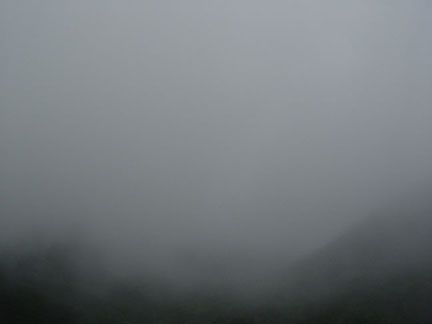
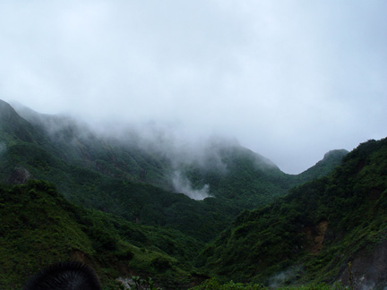
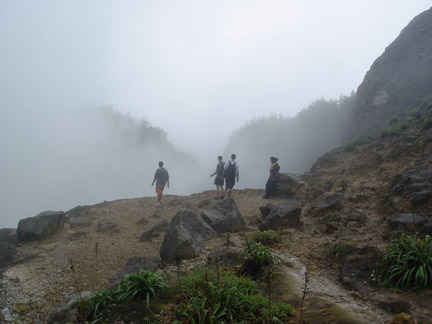
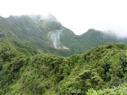
Number three, and not the least of the problems, was half of the time it looked just like this. It was rainy, foggy, and (if you remember from other Dominica pictures) the mountain tops are always in the clouds. We were walking over several of these mountains. Here is one of the mountains near us. Don't despair, though. The weather, and the clouds, got much better as the day wore on, and I got better pictures on the way back.
Right from the VERY beginning, the guys started appreciating why I wore sandals. It rains 350 inches a year here, and most of that during the 4-month rainy season. We were only half-way through it, and they had already had 370 inches of rain SO FAR. This means that there isn't EVER a time that the trails are dry. This also means that there are 365 streams and rivers, many of which cross the trails. There is also LOTS of mud. The first 20 minutes went a bit slow, as the guide and I walked briskly along the guys were hopping from side to side and on rocks and such. Their futile attempts to keep their shoes and socks dry appeared one at a time as each succumbed, finally, to some puddle or slippery log. Once this was over, we moved much faster.
Now, there is a reason why this hike isn't offered to the guests. It would not only be a liability waiting to happen, but it is also HARD. It would be hard, without a helicopter and rappelling equipment, to show exactly how steep the trail is. The mountains here aren't like the ridges of TN and NC, where the mountain is really high, but not that much higher than the surrounding landscape. The mountains here rise straight from the ocean floor, and steeply go to a peak, which then steeply goes to a valley. They look like caricatures or children's drawings of mountains. Here are a couple of pictures, which really don't do it justice. Their used to be a slightly shorter and easier trail, but during a hurricane it blew down a gigantic number of trees into it. Believe it or not, it was actually easier to build a new (and longer) trail from scratch than it was to clear the old one.
A small note about this is in order. I can't impress upon you how serious these guys are. My guide was one of just a couple of people out there to build the new trail. They had to figure out a way to actually get to the lake (without a helicopter or professional climbing equipment). Anyplace that was too steep had to have steps put in . . . or carved out of the rock. This all had to be done BY HAND, with hand tools, and without any mechanical way to get supplies. Every step was made of a log, split in half, laid flat-side-up. Then two small saplings would be cut and pounded into the ground in front of each step to keep it from rolling down the hill. It is a protected state park, so they weren't allowed to camp, which meant hiking out each day and hiking back. It also rains every day. Now, the guide DOES make money off of this (and got paid a small amount from the government to do it), but not a lot. He absolutely loves it here, and hikes out to the lake around 4 days a week (but usually only takes a tour there once every two weeks). The dedication to build this trail was just amazing.
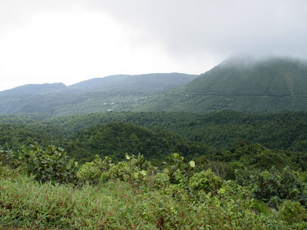
After we had been hiking for around 45 minutes, we came over the top of our second mountain peak. The view from the tops of these peaks (after the fog lifted) was just spectacular. Here is the valley that we were headed into, just as we are started down the other side.
I have to tell you, the beauty of this place is amazing. The vegetation is more lush than anything that I have ever seen. The mountains, while they don't have the height of large mountains in North America (or certainly other even bigger places), are rugged and spectacular. So much water is coming off of them that often the long string of steps looked like some landscaper's design of a stepped waterfall. Each step would pool water and then it would pour off the front for a vertical drop into the next pool steeply set under it. With each waterfall stair-step, each beautiful mountaintop view, each look at the mountains ahead, the same ever-present thought just kept running through my head:
I HAVE TO WALK BACK THIS WAY.
Now, I know that I am not in great shape. However, with the hiking that I had been doing, the long walks in the heat, and all of the stairs that I was using at work (I average between 900 and 1,000 steps UP every day), I figured that I was preparing somewhat for the hike. We weren't even a quarter of the way there before we started feeling the burning muscles and pain. In fact, one of the guys often kept asking if we were almost there, and one of us would reply with how long we had been hiking so far (only thirty minutes, just over an hour, etc.) The boiling lake is only at an elevation of 600 feet or so higher than where we started. The thought of hiking up 60 stories of stairs doesn't exactly come across as a walk in the park, but it doesn't seem that bad. However, you have to keep in mind that it wasn't just a hike up 600 feet, then a hike back down. We had to cross a peak that was 500 feet higher than the lake before we got there, and this was only one of four. Each time we had to go back down to a valley lower than where we started, and go back up. The steps are set at the nice 7 inches that steps in the ship are set at, they were often 2 feet apart. You wouldn't believe how different the muscles are to lift your foot two feet and haul yourself (and a backpack) up that two feet. In some places it was too steep for steps, and you had to just pull yourself up with roots and on rocks.
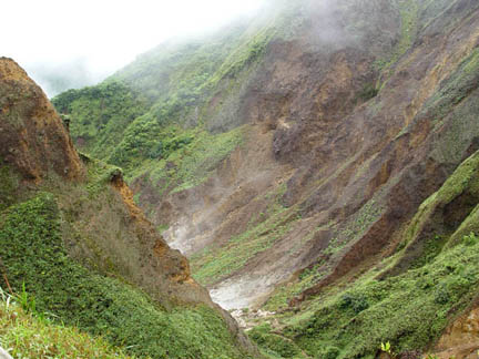
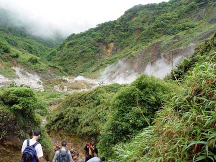
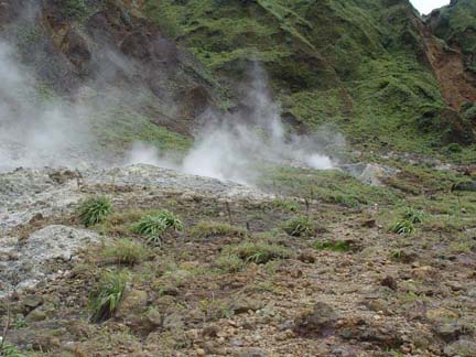
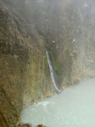
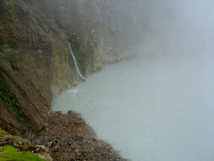
Back to the valley, which is called the Valley of Desolation. There, obviously, is a good reason for this. I don't know if you noticed in the last picture, but there is steam coming up the valley. As we rounded the corner, it looked more like this, and this. If you painted everything red, this is what movie portrayals of hell look like. Don't get me wrong, it was BEAUTIFUL. However, it definitely defines the word desolate. There is clay, intermixed with rock and sulfur. It smells like rotten eggs.
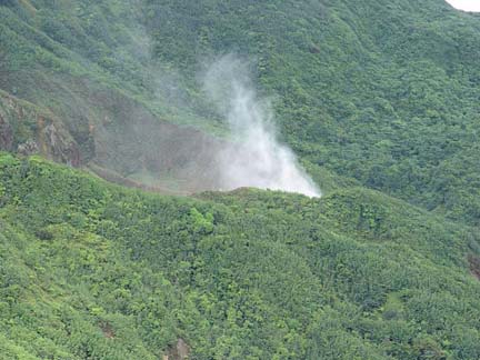
As I have mentioned before, this whole island is just made up of volcanoes, which are all now dormant. There is a subtle difference between "dormant" and "inactive." These aren't defunct, they are just sleeping. There are sensors on many of the mountains, measuring temperatures and vibrations. That way, at any time, if the mountain is going to blow they can have enough time to let everyone on the mountain know that very soon, they are going to die. There isn't any transportation off the island to speak of, and no one here has any money or way to go somewhere else. It would take an act of God or an amazing altruistic effort from another country to move everyone quickly. What all of this means is that there is a gigantic amount of pressure everywhere in the island. Luckily, rather than building it has places to vent. I have shown you pictures of the sulfur springs, which is one of those places. THIS is another.
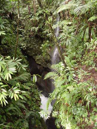
Since it is a valley between several mountains, there are streams coming down from everywhere. There are vents, blowing out huge amounts of steam. When you are crossing the streams, you have to be VERY careful. Some are rain runoff or natural springs, and are a bit chilly. Some are hot springs pouring out of vents, and will peel the skin off your leg if you happen misstep into one. There are tiny holes with nearly invisible steam issuing out of them, and large holes with columns of steam rocketing toward the sky like a missile that somehow is trying to burrow itself into the ground. There isn't a way to get a picture of this, as each one just looked like steam hovering over a hole, as if it were a pot of boiling water. The water coming out of these is around 350° (which is 138° hotter than boiling), as it is under such pressure underground that it can't boil.
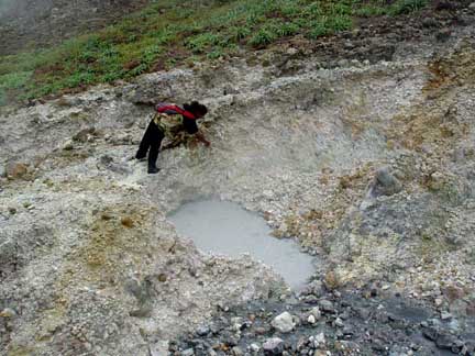
Here is our guide, pulling sulfur out of the rock around a small boiling puddle. Here is the puddle up close, you can see it boil. I have a video of the puddle and of one of the steam vents, but they take too much space for me to put on the web. In fact, I may have to go through the whole thing and reduce the size of all of my pictures. I am using up my web space at a rather frightening rate. :( Here is a picture of Ed. He wanted to have a picture next to one of the small steam vents, so he climbed down to it. He took a step back, and jumped as I have never seen someone jump before. The EXTREMELY hot steam went right up the back of his leg. As you can see in the picture, he is laughing, but was also in quite a bit of pain. He showed me the back of his leg Sunday morning before I left, it had the texture of stiff leather, and was red.
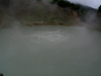
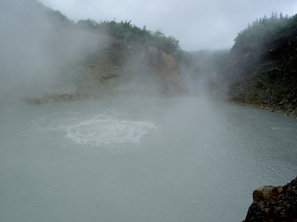
This was also the first time that we had an actual view of the lake, as we had just topped the highest peak. You can see a small pocket of steam on the side of the mountain, the lake is generating this steam. Now, the fact that it is called a boiling lake isn't some Carib Indian name for some lake with a lot of fog around it. This is an actual lake where the average water temperature is over 200°. The only thing that keeps it from being higher is the fact that cold water is pouring into it from lots of other streams. This used to be a mountain peak that blew off. Some of the ash was actually found in other countries afterwards. There is a constant plume of steam that is WAY over boiling temperature that makes the center of the lake boil, and supplies it with a constant supply of water. This then overflows the edge into a hot waterfall, this is part of where the hot water was coming from in the valley, even though it was a long ways away.
It didn't look that much farther, but distances are a bit deceiving. Here is another picture (zoomed in) as we got closer to the lake. Here Ed and Christian with the lake in the background. It doesn't look that big, but it is hidden behind edge of the hill that it is in. I had to take this picture on the way back, as it had really cleared up. Because of the weather and fog, I didn't take any more pictures on the way. It took a while too, as each time I would have to take off my pack, get out the camera bag, take out the camera, and then reverse it all. We were on a timetable, so I tried not to do this a lot. However, one of the guys was really slow, so it never ended up being a problem.
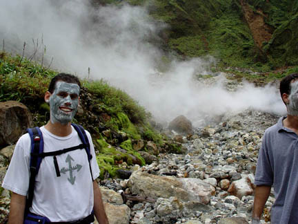
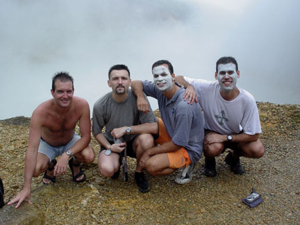
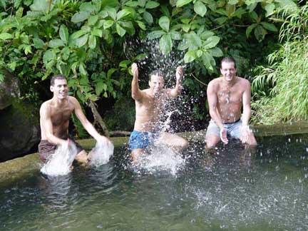
When we were in the valley, you saw the guide getting sulfur. He and two of the guys smeared their faces with this, it is supposed to be very good for the skin. Christian and I turned it down, but in some of these pictures you will see them with their faces covered. When we finally got to the lake, we were exhausted. There had been several places that had good drinking water, so we did that. We sat down at the top of the lake, and looked down into it. We had some snacks, and just kind of watched. He happened to mention, somewhat to our dismay (it had taken us just over three hours to get here) that he can do the hike in ONE hour. He's in fantastic shape, I'll tell you that.
The lake is the crater of the mountain, and when it blew it did it in an unusual way. Instead of a dish-shaped crater like you would normally see, it blew out a column vertically. So there is about a 100-foot vertical drop into the lake, there isn't any easy way to get down to the water. It is hot enough that I'm sure that it is more comfortable up on the ledge anyway. They aren't sure how deep it is, but they think that it is around 30 feet deep. It has dried up twice in the past hundred years, but then filled back up again (you'd think that they would have measured it when it was dry). There are several streams that run into it and keep it from just boiling away, one of the waterfalls was across where I could photograph it. I kind of feel bad with these pictures, they don't give you any kind of scale. As I look at them, the lake looks really small, but the waterfall you are looking at is around 5 stories high, if I were standing at the bottom of it you would barely be able to see me. These pictures are really zoomed in, and I don't have a wide-angle lens, However, you can see the trees along the top edge, which should give you an idea of how far away I am. They aren't small bushes, even though they look like it in the picture. You can see the gap where the lake overflows to the valley below. You can see near the center where the steam and hot water is blasting up from below. From 30 feet down it is hot enough to make the top of the water bubble and gurgle as if someone had a huge fire hose just under the surface, and the temperature makes it froth and foam as it boils.
As you can imagine, a boiling lake generates a LOT of steam and a lot of heat. Each time the wind would blow, it would get very hot, and it was really difficult to take pictures. We spent the better part of a half-hour standing near the edge, waiting for the breeze to blow away enough steam to snap a picture. Here is a picture while I was waiting for the breeze. Here is another of us at the edge, you can't even see the lake behind us. An interesting side-effect of all of the sulfur is that jewelry turns colors from it. My necklace chain is sterling silver, and it turned the same color as the copper/brass-colored coin attached to it (it was really shiny silver when we started the hike). He said that with toothpaste it would come right off, but I left it as it matched the coin better. It took about a week to wear off.
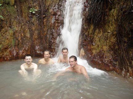
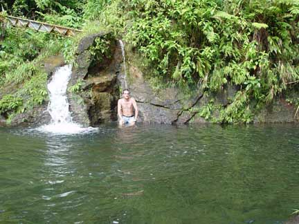
We were really short on time, so we didn't get to rest as much as we liked. We also wanted to soak a bit in the "natural hot tub" on the way back. It was nice, but it is usually around 103 - 105° (the temperature of a fairly hot home hot tub). Today it was only around 100°, as all of the rain had mixed cold water with it. We didn't have much time here, so after a few minutes we pressed on. I got a great view of the valley, the lake (zoomed in), and the lake again on the way back . . . it had cleared up a lot.
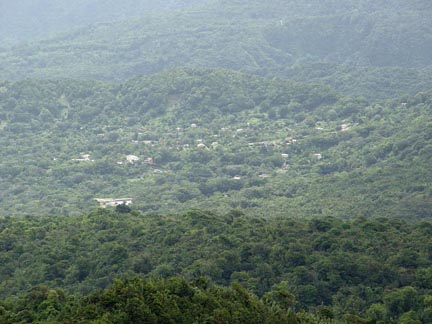
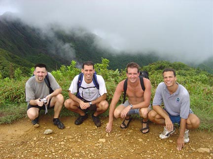
When we got back to the top of the high peak, we could now see all the way to the ocean. You can see the mountain (still shrouded in clouds) and some buildings below it to the left. Here is a closer picture of the buildings when I zoomed in. This was where we started the hike, which also meant it was how far we still had to hike back. The guys had rinsed off their faces in a stream just before, so we took another group photo.
I pretty much stopped taking photos at this point, and concentrated on breathing, and the building pain in my upper legs when going uphill. Then, going down the steep hills and stairs I got to experience the burning pain in my calves. With the clearing weather came higher temperatures, so I also started drinking a lot more water at the streams. Ed actually slipped a bit off of the log that he was stepping on, and ended up severely in the mud. It took a few minutes for him to get out, particularly without losing his shoes.
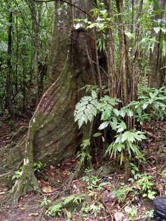
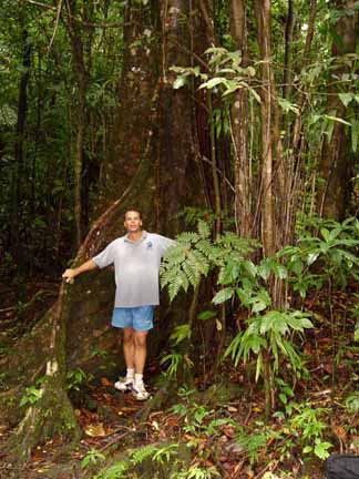
Some of the trees have really cool roots here. They flare out from up above and go into the ground, but not like a banyan tree. Here is another picture to give you an idea of scale. They are more like fins, as they stay attached to the tree at every point rather than moving, air-like, out and away from the tree. They remind me a bit of a natural flying buttress.
Now that the sun was overhead, enough light was filtering down through the trees for me to actually take a decent picture of the crack in the rock in which I swam. I couldn't get to a place to shoot the waterfall at the end, though. I was far enough ahead of all of the other guys at this point that I had time to swim up it again. Ed caught up with me and joined me, so we same back up to the waterfall. This was a minor mistake, as (believe it or not) my legs were really tired. About three-quarters of the way to it the combination of sore muscles and cold water caused my legs to cramp like you wouldn't believe. I wasn't in too much danger, as there were lots of shallow places and people near enough to hear if I had yelled (including Ed, who was close by but potentially could have the same problem). If I just floated on my back I'd drift back to the entrance, as the water is moving pretty fast. So, I let myself drift until I hit a shallow spot, then hung on for a minute 'till the cramps went away. It is really cool to just be floating, looking up through the crack and the light filtering through the trees.
I didn't make it quite to the fall, but I couldn't take a picture of it anyway. I just laid back and floated on my back (steering myself between the rocks) until I got back to the open water. I decided to sit under the hot water again for a minute. Unfortunately it was blocked, so not much was coming through, and the rain had cooled it considerably. It was nice anyway. The cold water felt really good too, as we had been pretty hot. It never gets really bad, though. There is cool water everywhere, and the tree coverage keeps you from the sun the whole time.
Here is the entrance to the trail, they warn you of the distance, the fact that you should have a guide, and that everything there is protected. Because all of the Wacky Roller people were now coming, we had gotten out of the water and were heading back. We actually made good time on the way back, and we ate some of the fruit that they were offering to the Rollers tour (our guide also works with them). They also had fresh avocado this time, which I love.
I know that this is long, but I want to relate one more story (about how our guide found that he can make the trip in an hour). There is another tour guide who also takes people to the lake. He had a small group, and one guy happened to drop his camera and it went over the edge. It got hung on the strap a little ways down, so it didn't break. They left it and hiked back. The guide, however, is a bit of a crack-head (literally, not figuratively). He used up that day's guide money on drugs, and needed more. He decided to run back up to the lake with a rope and get the camera to bring back to sell. As he was climbing down the rope kind of ran back and forth across the sharp rocks and let him loose.
He dropped quite a distance, luckily right into the right place. If he had fallen over the edge by where the pictures of us were taken, he would have been killed. As it was, he fell into the boiling water, and hastily pulled himself ashore. The fact that he got out of the water at all is amazing, and he had third-degree burns over an awful lot of his body. He was there quite a while before anyone else came along (which was sheer luck, as many days there isn't anyone there). They called for help, and he heard about it on the radio. He literally ran the whole way to the lake, and got there in just under an hour. Now, you used to be able to take a helicopter to the lake, but it was disturbing the birds and their nests so much that it was outlawed. So, that being the only helicopter on the island, the guy went to another island. They actually had to carry the guy all the way back up this trail to take him to an ambulance. He was in incredible pain, and the trail is harsh. He actually lived through it all, and after a lot of hospital time and skin grafts he is now o.k. He learned one very important lesson in all of this . . .
He now stands quite a ways back from the edge when he goes to the lake.
Yes, he still takes drugs and no, he didn't get the camera.